-
Please read the new forum rules! REQUIRED!
Click Here: https://www.gulfcoastgunforum.com/threads/general-forum-rules-code-of-conduct.70770/
-
New Reloading Sticky Thread for Trading, Swapping Gear, etc.
https://www.gulfcoastgunforum.com/threads/reloading-components-for-trade-item-value-and-photo.104847/
You are using an out of date browser. It may not display this or other websites correctly.
You should upgrade or use an alternative browser.
You should upgrade or use an alternative browser.
Ian storm
- Thread starter polebarn
- Start date
The #1 community for Gun Owners of the Gulf Coast States
Member Benefits:
Fewer Ads! Discuss all aspects of firearm ownership Discuss anti-gun legislation Buy, sell, and trade in the classified section Chat with Local gun shops, ranges, trainers & other businesses Discover free outdoor shooting areas View up to date on firearm-related events Share photos & video with other members ...and so much more!
Member Benefits:
I posted that in jest. As in, I'm leaving Tuesday morning heading to those areas affected.Jefferson County could be hard hit.Not a dumpster fire to those affected JW.
polebarn
Expert
Appreciate that and the work you guys do.I posted that in jest. As in, I'm leaving Tuesday morning heading to those areas affected.
Safe Travels!I posted that in jest. As in, I'm leaving Tuesday morning heading to those areas affected.
Stay safe brother!I posted that in jest. As in, I'm leaving Tuesday morning heading to those areas affected.
BluesBrother
Master
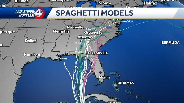
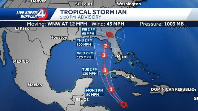
No one knows but the 5:00 PM Sunday cone of uncertainty modeling have it going into the Bid Bend area. I hate it for them if that happens. I'm going to hate it even worse if the modeling swings west.


Jstocks
Expert
I don’t want to wish it on anyone, but I’m out of the country at work and I sure don’t hope my wife and 3 kids have to deal with it on a serious level.
I lived in Picayune, Mississippi when Katrina hit in 2005. That took enough out of me that I’ll never stay for another one. It’s not worth it to me.
Y’all South Alabama/Pensacola area fellas get ready. Murphy’s Law is following me like stink on lately. Hell, I’d be scared for Texas if I lived there right now it’s follow me there.
at least the big bend area is sparsely populated..No one knows but the 5:00 PM Sunday cone of uncertainty modeling have it going into the Bid Bend area. I hate it for them if that happens. I'm going to hate it even worse if the modeling swings west.
View attachment 186016 View attachment 186019
They are sending you kinda early aren’t they?I posted that in jest. As in, I'm leaving Tuesday morning heading to those areas affected.
Where are you going to stage?
Fodderwing
Marksman
It's not all prestige and glory, there's another incentive... View attachment 186070
Not sure at the moment, somewhere in the cone area I guess. HahaThey are sending you kinda early aren’t they?
Where are you going to stage?
M118LR
Master
Guess Thing 1 picked the wrong two weeks to Honeymoon at the theme parks. Sea World just shut down so they will be spending Wednesday slowly packing, and They aren't scheduled to move to the Disney Grand Floridian until Thursday. But Disney & Universal have closed both Wednesday & Thursday so we shall see how that works out. I supposed to take Thing 2's crew (the Redheaded Grandson included) to LEGOLAND Sat, Sun, & Mon with hotel check in on Friday but that may need a little shuffling dependent on post IAN power restoration. Looks like US Folks here in Clay county are going to get IAN coming and going, but Hopefully it won't be near as BAD as those under landfall right on the Gulf Coast. Glad to hear the panhandle seems to have dodged a major bullet, and I hope ALL the Folks in central Florida fair well. It's going to be strange to not suit up for a Hurricane, but it's time to let the Young Bucks ride the cable to rescue folks up on the roof. Stay safe Y'all.
BluesBrother
Master
5 P.M. ADVISORY: Hurricane Ian maintains Category 3 strength
Hurricane Ian is maintaining its strength as a Category 3 storm with 120 mph winds.The storm is located about 230 miles south of Sarasota, Florida, and is moving north at 10 mph.
The forecast calls for Ian to become a Category 4 hurricane with 130 mph winds by Tuesday night. From there, it is forecast to make landfall just south of Sarasota, Florida, by Wednesday night as a Category 3 storm with 125 mph winds.
Members online
- Daezee
- Fred6964
- BluesBrother
- cutchy32
- Spearhead
- McMillan
- DSPLCD1
- duckhunter
- garryj
- Methrentus
- Metal Storm
- lil'skeet
- JHH625
- sarge1644
- flkahr
- Midnight son
- Rockola2004
- VCaskey
- Gunrunner96
- Moss
- jugdish
- Islandtactical
- Rebel_Rider1969
- StayingFrosty
- rkflorey
- Boogan1
- FrommerStop
- Rupven
- zdiver99
- DAS HUGH!
- Senojeelnodnarb
- boondoggle
- Acyr51
- timc
- Sgump
Total: 593 (members: 41, guests: 552)


